Saturday, May 30, 2009

Severe Thunderstorm Warnings: How to Make Them More Effective

We've all been under one of these "severe" storms. Some of us have seen the quarter sized hail; some have experienced the 60m.p.h. winds. This all ails in comparison to what some experience, and have the same alert for.

I'm sure you all remember the MCS that struck southern Missouri earlier this month. You can see the NASTY satellite imagery on the left. As this storm barreled across southern Missouri, it produced winds in excess of 100 miles per hour in some spots, but in most places about 80 m.p.h., which is still VERY dangerous. You can see some horrific damage to a station that is still not on air.
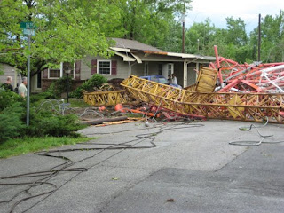
How were the average people in the path of this storm supposed to know how dangerous this storm was as it barreled towards them? They were under a severe thunderstorm warning. They probably shrugged that off of their shoulders saying something like, "Oh, this happens ALL of the time," and went on doing what they would have done normally during a thunderstorm. What would you do?

If you just heard, "A severe thunderstorm warning has been issued for your county," with your weather radio, would you necessarily listen to the rest of the statement? Some might, and take proper action; some may, and still underestimate the risks, even though it says winds in excess of 80 miles per hour; some may not hear the wind speeds at all, and just stay inside their un-safe-for-bad-storms area.

This is why people want to change the rating system for severe thunderstorm warnings. An example would be one of my thoughts below:

>STORM WARNING : Same criteria, and people should still take the basic precautions.

>PARTICULARLY SEVERE STORM: Wind gusts in excess of 80. Great damage is LIKELY if you are in the direct path of this storm. People should take the same precautions as for a tornado. Here is an example.
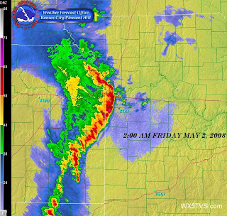
>TORNADO WARNING: A tornado is on the ground in your area, or is soon likely to come. Take tornado precautions IMMEDIATELY.


As you can see, this would give a 3 level system:

>The basic warning would be issued that would be common and tell the people to just take basic thunderstorm precautions, and to be ready for some potentially gusty winds.

>A warning would be used less commonly, thus taken more seriously. This would basically state a very rare, very dangerous storm is coming your way, and you should take the same precautions as for a tornado.

>A tornado warning would actually mean there's a tornado ON THE GROUND, or one is eminent, and you should take tornado precautions

There are many more pros and cons to this "3 alert level system" I have made up. Many changes can be made, and I'd love to hear them.

Have ideas on how to make this better or questions? POST THEM PLEASE!!! Anybody can.

5-30: Dewpoints and Possible Outflow Boundaries

Good Saturday everyone!

Some of you this morning may have felt some sprinkles come over your area, especially in the northern and eastern parts of Missouri... right? Well, the SPC has parts of the state now in a 5% risk of severe weather (not even slight risk!), and once again, that might be overdone.

The moisture once again today is very minimal. Models keep saying, "The dewpoints will be high!" As they keep transferring what they think, we can still tell they're wrong. For example, up here near Kansas City, we have a temperature in the 70s this morning with dewpoints in the 50s.

Models are forecasting that the dewpoints could hit 70. As we look into our surface flow from the north, we can tell that their dewpoints aren't any higher; at the most, they are 58 degrees. If we kept getting flow from this direction, that would say a dewpoint of up to 58, but with evaporation from bodies of water, and transpiration from plants, we could get higher than that.

We cannot get any moisture advection either, as the flow aloft is from the NW. This would mean that to get to the dewpoint of the models, we would have to get at LEAST, 12 degrees more on the dewpoint JUST from evaporation and transpiration. THAT IS NOT going to happen. The most I have ever seen is 8 degrees, and that was last year at Whiteman AFB, where they just had like 3" of rain, and the ground was VERY saturated from the whole wet summer in general. So, do you think that's going to happen today, with a SLIGHTLY moist ground. IT'S NOT!!!

Now that we know moisture is out of the way, let's talk about the other factor today-- outflow from morning sprinkles. Sometimes, when a group of showers or thunderstorms die out, especially in the summer months, they will let out cool air around them, which acts kind of like a cold front.

I have not seen any of these yet today, but there likely are some, just not very detectable. Sometimes you can see them on radar, like shown on the side.

This, along with the WEAK wind shift in southern Missouri, could spark of some thunderstorms here in Missouri, but most likely NOT! You can see the very weak wind shift below. If storms do form though, they would move from northwest to southeast, as shown by the flow aloft.


Well, everyone, have a lovely weekend, as it will be a warm one, with temperatures near 90 in parts of Missouri. Just keep your eyes to the skies, but don't change your plans! Chance of precipitation in my opinion this afternoon: 15%, mostly in southern Missouri.

Friday, May 29, 2009

5-29 Slight Risk: Nothing to Worry About

You may have already heard, but as of this morning, the northern part of Missouri has been placed under a SLIGHT risk of severe weather. This kind of came out of the blue, but is still nothing to worry about.

The culprit of this Slight Risk is a very weak wind-shift line, and let me emphasize "weak". With this boundary, there may be a small amount of lift, but as we all know, with temperatures in the 80s, it doesn't take much to get something started.

With convergence, there is nowhere to go but up. For example, when North Winds meet south winds, you may wonder where the air goes when they meet. It's simple. They can't go down, so they go up. You can see that in today's front.

Since the convergence is "weak", as noted by weak air speeds hitting each other, they will not be able to go up as fast as a strong convergence, which would send air upwards even faster.

If there are ANY risks with this set-up, it would be hail, and secondarily wind. The tornado risk is VERY small. These storms would be VERY isolated, if they even develop at all, so when looking at SPC outlooks for today, the word "slight" should be token to mind greatly.

As for if you should be worried, I would say you have nothing to worry about if you live south of U.S. Highway 36, you do not have to worry about severe weather, and if you live to the north, just be ready. Be sure to just enjoy your day, as the chance of getting rain at your house is still only about 30%. That is a 70% chance IT DOES NOT happen.

The main concern for today is lightning. If you hear thunder, go inside or get in a car. If you suspect a developing thunderstorm, get inside, as you could be near, or even struck by the first strike.

In terms of tropical depression 1, since it did not become a tropical storm overnight or this morning, the risk of becoming a tropical storm has went down more. It is still possible, but very unlikely. That map shows that fact with the VERY low chance of it becoming a tropical storm with greater than 39mph winds.


10PM Update: TD1 Has lost ALL tropical characteristics, thus, dropping the chance of becoming a tropical storm.
Enjoy a nice, summer-like day! Remember your lightning safety!

Thursday, May 28, 2009

UPDATE!!! "Some" Action After a Long Break.

Well, after breaking records for the longest May stretch without severe weather watches, we look to the future and see a "slightly" higher risk of severe weather.

We'll start off by looking at your Friday: We will likely warm up GREATLY across the state of Missouri and the surrounding areas. We will be most likely br in the 80s throughout the state. Humidity, which is an important ingredient for severe weather will "kind of" come up this way. The flow from the Gulf of Mexico is there... but yet not very much. It isn't anything you'd see for a good outbreak.

On Saturday, it appears there will be a trough somewhere to the northwest of Missouri, most likely in the Wyoming, Nebraska, and South Dakota areas. This, along with some instability could lead to some storms popping up in Nebraska, and with the flow aloft from the northwest, these would likely come in to northern Missouri.

The only problem is, is that the flow of moisture from the Gulf will not be strong enough to create shear in the area. The heat and humidity will be there, but without shear, it will be hard for these storms to stay together. With that being said, there is a VERY SLIGHT risk of severe weather in Missouri, with the highest, yet very minimal chance being in Northern and Northeastern Missouri.

As we look after that, the trough seems like it will move east even more, and there will be a VERY SLIGHT risk of severe weather just to the northeast of Missouri, in Iowa and Illinois. It cannot be ruled out that one may come into the Kirksville area, but that risk is also very slight.

As we go into next week, another cyclone will come and eject itself out into Kansas, and a warm front will set itself up in the Missouri area, with storms along and north of this front. There could be some severe weather in far northern Missouri from this system, as it will have better air-dynamics, but it still isn't a great chance. Just stay tuned. Still a weak flow as depicted below.

I would not be worried about severe weather for the next several days WHAT-SO-EVER if you live south of U.S. 36 Highway in Missouri. Even if you do live north of that line, your chances are still VERY LOW! Just enjoy the upcoming warm, summer-like weather! =)

Has anybody heard of tropical depression 1 yet? It is just of the Cape of Massachusetts area, and as it goes to the Northeast, it may strengthen to a tropical storm status. Nobody is at risk by this storm though, as it will likely wash out within 4 or 5 days, and there are no land-masses in its path.

You can see the 40% risk of this depression becoming a tropical storm, in which appears to maybe be a little low due to the warm gulf stream. On this blog, I'd put it at about 60%. It will run into very minimal shear though, and tropical cyclones DO NOT like that.

Have a great weekend, as it shall be the last one of May, and it will be a good finale!

***Questions? Please ask!!! Comments are GREATLY appreciated too! Anyone can post on this blog!

Saturday, May 16, 2009

5-17-09: Looking Ahead to a Lovely Week

This up-coming week looks to be VERY calm for the first 4 days at least. Friday looks to maybe have thunderstorms, but it is too early to really tell still. I'd put the chance at about 15%. Not very high. Severe risk is VERY VERY VERY low as of now.

The weather pattern looks to be warmer also. We will begin our return flow on Sunday late, and it shall be very warm for the rest of the week. Temperatures will be in the mid to upper 80s as we head through the rest of the week, and as we get towards the end, we may actually be speaking a VERY MINOR heat index, all depending on our return flow of moisture.

“Could there be any risk of severe weather for Friday?” HECK NO!!! I will keep you posted as we head towards that time, but for now, enjoy the week ahead!

5-16-09: A Look Back at This Week

We had 2 days of severe weather across Missouri this week:

1)WEDNESDAY: Tornadoes in Sullivan, Linn, and Adair Counties.

2)FRIDAY: Major flooding from a stubborn line of storms. Some hail. Awesome Outflow boundary

The tornadoes Wednesday were by far the most impressive of the week. There was nothing spectacular, but a tornado still managed to produce major damage in the Kirksville area. There were some injuries from this storm too.
On Friday, there were no tornadoes in the area, even though we were under a 10% risk of tornadoes and a Moderate risk of severe weather. Major flooding was reported just north of Kansas City as a strong line of storms produced up to 6” of rain. Roads were covered with water.
A “outflow boundary” of cool air from the storm produced some low-hanging shelf clouds. Some thought it was a rotating wall cloud. It was nothing serious thankfully, but an awesome cloud formation.

Sunday, May 10, 2009

5/10/09 Look Ahead to next week-

Hello Bloggers! Next week, there are 2 days that are currently highlighted by the Storms Prediction Center in Norman, OK that have our attention here in Western Missouri. They are not serious, but they are as follows:
For Tuesday, there is a slight risk of severe weather that extends from the Texas pan-handle, northward, to the western part of Nebraska. This looks to be the area with the best chance of severe weather, but there is a chance that this risk could be spread further to the east, and encompassing most of Kansas. This scenario will likely have updates.
For Wednesday, the SPC has already put out a 30% risk out for central Missouri, parts of Iowa and Illinois, and all of the way to SE Kansas and northern Oklahoma. There is a well-defined jet and an okay storm system, but will there be a good boundary and supple humidity and heat? We will likely know as we get closer.
As for both days, “could we have another MCS or derecho?” is the thought on the minds of many in southern KS, MO, KY, and all of the way to the Atlantic. Well, all I can say is, “I hope not!”

Severe Weather Blog 5/10/09- Missouri Hurricane!

On Friday’s early Morning, (5-8-09) a major complex of storms formed over western Kansas. This large, strong complex of storms was then able to grow so large, that it rotated counter-clockwise after gaining enough size. (Same process happens with tropical storms). This so called “derecho” or “MCS” had begun producing VERY dangerous winds, with gusts over 80 miles per hour over eastern Kansas. As it moved along to the Missouri state line, this cyclone had became stronger; it was now producing wind gusts to 100 miles per hour in some spots. This was strong enough to destroy many houses in the Joplin area and even knock down the tower to their NBC affiliate.
As it kept going, its damage trail continued. In Springfield, the storm was enough to damage schools. Thankfully, no students were hurt; they were in their safe place in the hallways. Shortly after the massive bow-echo hit Springfield with extreme winds, an amazing phenomenon was noticed; this massive MCS had formed and eye! It was noticed on satellite imagery and later, as it entered Illinois on radar too.
This massive storm had formed in Kansas and went all of the way to the Atlantic. Much damage was noted in its path, and many tornado warnings were issued. There are currently no estimations on damage from this storm. As we head into the future, the storm reports from this deadly phenomenon will be edited and finalized